- 427.00 KB
- 2023-11-30 发布
- 1、本文档内容版权归属内容提供方,所产生的收益全部归内容提供方所有。如果您对本文有版权争议,可选择认领,认领后既往收益都归您。
- 2、本文档由用户上传,本站不保证质量和数量令人满意,可能有诸多瑕疵,付费之前,请仔细先通过免费阅读内容等途径辨别内容交易风险。如存在严重挂羊头卖狗肉之情形,可联系本站下载客服投诉处理。
- 文档侵权举报QQ:3215808601
Unit Three:
Meteorological Forecasts
第三课:气象预报
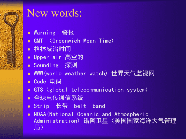
New words:
Warning
警报
GMT
(
Greenwich Mean Time)
格林威治时间
Upper-air
高空的
Sounding
探测
WWW(world weather watch)
世界天气监视网
Code
电码
GTS
(
global telecommunication system)
全球电传通信系统
Strip
长带
belt band
NOAA(National Oceanic and Atmospheric Administration)
诺阿卫星(美国国家海洋大气管理局
)
GOES (geostationary operational environment satellite)
地球静止业务环境卫星
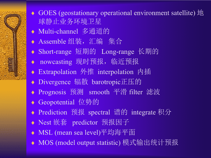
Multi-channel
多通道的
Assemble
组装,汇编 集合
Short-range
短期的
Long-range
长期的
nowcasting
现时预报,临近预报
Extrapolation
外推
interpolation
内插
Divergence
辐散
barotropic
正压
的
Prognosis
预测
smooth
平滑
filter
滤波
Geopotential
位势的
Prediction
预报
spectral
谱的
integrate
积分
Nest
嵌套
predictor
预报因子
MSL (mean sea level)
平均海平面
MOS (model output statistic)
模式输出统计预报
Thunderstorm
雷暴
hurricane
飓风
Typhoon
台风
Subgrid
次
网格
Substructure
n.
次级结构
sub+…
亚;次级;下级 (构词法)
Subtropic
副热带,亚热带
Unpredictable
不可预报的
predictable
可预报的
Predictability
可预报性
Frame-work
框架
Topographic
地形的
orographic
Gust
阵风
tornado
(
陆)龙卷
Freezing
冻结的
Doppler(radar
)
多谱勒雷达
Index(indices)
指数
shear
切变
Downburst
下击暴流
Serve as
充当,作为
P1①National Meteorological Services perform
a variety of
activities in order to provide weather forecasts. ②The principal ones are data collection, the preparation of basic analyses and prognostic charts of short-and long-term forecasts for the public as well as special services for aviation, shipping , agricultural and other commercial and industrial users, and the
issuance
of severe weather warnings.
1. Data sources
P2:
①
The data
required for forecasting and other services
are provided by worldwide standard synoptic reports at 00, 06, 12, and 18 GMT, similar observations made
hourly
, particularly
in support of
national aviation requirements, upper-air soundings (at 00 and 12 GMT), satellite data and other specialized networks such as radar stations for severe weather .
②
Under the World Weather Watch (WWW) program, synoptic reports are made at some 4,000 land stations and by 7,000 ships.
③
There are about 700 stations making upper-air soundings (temperature, pressure, humidity, and, wind).
④
These data are transmitted in code via teletype and radio links in regional or national centers and into the high-speed Global Telecommunications System (GTS)
connecting World Weather
Centres
in Melbourne, Moscow and Washington and eleven Regional Meteorological
Centres
for redistribution
.
⑤
Some 157 states and territories cooperate in this activity
under the aegis of
the World Meteorological Organization (WMO).
P3:
①
Meteorological information has been collected operationally by satellites of the United States and USSR since 1965 and, more recently, by the European Space Agency, India and Japan.
②
There are two general categories of weather satellite: polar orbiters
providing global coverage twice per 24 hours in orbital strips over the poles (such as the Unites States NOAA and TIROS series, and the USSR’s Meteor)
and geosynchronous satellites
(such as the Geostationary Operational Environmental Satellites (GOES) and
Metosat
)
,
giving repetitive(30-minute) coverage of almost one third of the earth’s surface in low middle latitudes
.
③
Information on the atmosphere is collected as digital data or direct readout visible and infrared images of cloud cover and sea-surface temperature, but also includes global temperature and moisture profiles
which receive radiation emitted from particular levels in the atmosphere
.
④
Additionally, satellites have a data collection system (DCS) that
relays
data on numerous environmental variations from ground platforms or ocean buoys
to
processing
centres
;
⑤
GOES can also transmit processed satellite images in facsimile and the NOAA polar orbiters have an automatic picture transmission (APT) system that is utilized at 900 stations worldwide.
2. Forecasting
P4:
①
Modern forecasting did not become possible until weather information could be rapidly collected, assembled and processed.
②
The first development came in the middle of the last century with the invention of telegraphy,
which permitted immediate analysis of weather data by the drawing of synoptic charts
.
③
These were first displayed in Britain at the Great Exhibition of 1851.
④
Sequences of weather change
were correlated with
barometric pressure patterns both in space and time by such workers as Fitzroy and
Abereroleby
, but it was not until later that
theoretival
models of weather system were devised——notably the
Bjerknes
depression model.
P5:①Forecasts are usually
referred to as
short-range, medium (or extended) range and long-range. ②The first two can
for present purposes
be considered together.
Short-range forecasting
P6:① Forecasting procedures
developed
up to
the 1950s
were
based on
synoptic principles but, since the 1960s, practices have been revolutionized by numerical forecasting models and the adoption of “
nowcasting
” techniques.
P7: During the first half of the century, short-range forecasts were based on synoptic principles, empirical rules and extrapolation of pressure changes.
P8:①Since 1955 routine forecasts have been
based on
numerical models. ②These predict the evolution of physical processes in the atmosphere by determinations of the conservation of mass, energy and momentum. ③The basic principle is
that the rise or fall of surface pressure
is related to
mass convergence or divergence, respectively, in the overlying air column.
P9:
①
Forecast practices in the major national
centres
are basically similar.
②
The forecasts are essentially
derived from
twice-daily (00 and 12 GMT) prognoses of atmospheric circulation.
③
Since most techniques are now largely automated, the analyses of synoptic fields are based on the previous 12-hour forecast maps as a first guess.
④
Three different interpolation methods are used to obtain smoothed,
grided
data on temperature, moisture, wind and
geopotential
height for the surface at standard pressure levels (850,700,500,400,300,250,200 and 100
mb
) over the globe.
⑤
The NMC currently has two basic prediction models: a special model with (6 or) 12 layers (from the boundary layer into the upper stratosphere), which is integrated for up to 10 days, and a regionally applicable nested grid model with finer horizontal resolution.
⑥
It should be noted that
typically the computer time required increases several-fold when the grid spacing is halved.
⑦
The essential forecast products are MSL pressure, temperature and wind velocity for standard pressure levels, 1000-500mb thickness, vertical motion and moisture content in the lower troposphere, and precipitation amounts.
P10:
①
Actual weather conditions are now commonly predicted using the Model Output Statistics(MOS) technique developed by the US National Weather Service.
②
Rather than
relating
weather variable
to
the predicted pressure/height patterns and
taking account of
frontal models, for example, a series of regression equations are developed for specific locations
between
the variable of interest
and
up to 10 predictors calculated by the numerical models.
③
Weather elements
so
predicted for numerous locations
include
daily maximum/minimum temperature, 12-hour probability of precipitation occurrence and precipitation amount, probability of frozen precipitation , thunderstorm occurrence, cloud cover and surface winds. ④These forecasts are distributed as facsimile maps and tables to weather offices for local use.
P11:
①
Errors in numerical forecast
arise from
several sources.
②
One of the most serious is the limited accuracy of the initial analyses
due to
data deficiencies.
③
The average over the oceans is sparse and only a quarter of the possible ship reports may be received within 12 hours; even over the land more than one-third of the synoptic reports may be delayed beyond 6 hours.
④
However, satellites-derived information and aircraft reports can help fill some gaps for the upper air.
⑤
Another limitation is imposed by the horizontal and vertical resolution of the models and the need to parameterize
subgrid
processes such as cumulus convection.
⑥The small-scale nature of the turbulent motion of the atmosphere means that some weather phenomena are basically unpredictable, for example, the specific locations of shower cells in an unstable air mass. ⑦ Greater precision that the “showers and bright periods” or “scattered showers” of the forecast language is impossible with present techniques. ⑧The procedure for preparing a forecasting is becoming much less subjective, although in complex weather situations the skill of the experienced forecaster still makes the technique almost
as much as
art as a science. ⑨Detailed regional or local predictions can only be made within the framework of the general forecast situation for the country and demand thorough knowledge of possible topographic or other local effects by the forecaster.
Nowcasting
P12:① Severe weather is typically short-lived(<2 hr ) and, due to its
mesoscale
character(<100km), it affects local/regional areas
necessitating
site-specific forecasts. ②Include in this category are thunderstorms, gust fronts, tornadoes, high winds especially along coasts, over lakes and mountains, heavy snow and freezing precipitation. ③
The development
of radar networks, now instruments and high-speed communication links
has
provided a means of
issuing warnings
of such phenomena.
④ Several countries have recently developed integrated satellite and radar systems to provide information on the horizontal and vertical extend of thunderstorms, for example. ⑤ Such data are supplemented by networks of automatic weather stations (including buoys) that measure wind, temperature and humidity.
⑥
In addition, for detailed boundary layer and lower troposphere data, there is now an array of vertical sounders
——
acoustic sounders (measuring wind speed and direction from echoes created by thermal eddies), specialized (Doppler) radar measuring winds in clear air by returns either from insects(3.5 cm wavelength radar) or from variations in the air’s refractive index(10 cm wavelength radar).
⑦
Nowcasting
techniques use highly automated computers and image analysis systems to integrate data from a variety of sources rapidly.
⑧
Interpretation of the data displays requires skilled personnel and/or
extensive
software to provide appropriate information. ⑨ The prompt forecasting of wind shear and down-burst hazards at airports is one example of the importance of
nowcasting
procedures.
P13:①
Overall
, the greatest benefits from improved forecasting can be expected in aviation, construction and the electric power industry for forecast less than 6 hours ahead, in
transpiration
, construction and manufacturing for 12-24 hour forecasts and in agriculture for 2-5 day forecasts.
②
In terms of
economic losses, the last category could benefit the most from more reliable and precise forecasts.
Long-range forecasting
P14:① The methods discussed above are unsuitable for predicting the probable trend of the weather for periods of a month or more, because they are concerned with individual synoptic disturbances with a life cycle of about 3 to 7 days. ② Theoretical considerations indicate that the limit of synoptic predictability using numerical techniques is less than 15 days. ③Two rather different approaches will be
dealt with
later.
缩略语含义以及读法
连起来读:
NOAA NASA NCAR
等
NOAA:
National Oceanic and Atmospheric Administration
诺阿卫星(美国国家海洋大气管理局
)
NASA
:
National
Aeronautic
[ɛrə'nɔtɪk
]
and Space Administration(
美)国家航空航天局
NCAR
:
National Center for Atmospheric Research(
美)国家大气研究中心
NCEP :National Center for Environmental Prediction
美国国家环境预报中心
读字母发音的:
WMO NMC NCC
等
NMC :National Meteorological Center
国家气象中心
NCC
:
National Climatic Center
国家气候中心
CMA: China Meteorological Administration
CMS : China Meteorological Society
GMT: Greenwich Mean Time
格林威治标准时
LASG
:
State Key Laboratory of Numerical Modeling for Atmospheric Sciences and Geophysical Fluid Dynamics
大气科学和地球流体力学数值模拟国家重点实验室
TBB: Temperature of black body on the top of cloud
OLR: outgoing long-wave radiation
JMA
日本气象厅
GMS
静止气象卫星